Background (originally posted summer 2017)
At the end of the outlet on the north end of David Pond, a dam has been in place since the early 19th century when several mills were located near Sandy River Road. When these water powered mills became inactive in the early 20th century, remnants of the structures that were in place started to decay. Local residents repaired the dam structure at the outlet to maintain the water level that had existed since 1805. The continual restoration of the dam has been a tradition up to the present time.
Over the course of the last few years, the water flow has been disturbed on repeated occasions by vandalism. A beaver dam was destroyed, and other materials (rocks and wood) were removed. These illegal acts caused water to rush out of David Pond, and so local residents made repairs to the dam structure in order to stop the drastic water level change that was occurring. This cycle of destruction and restoration happened several times.
The Maine Department of Environmental Protection (DEP) became involved early summer 2017, and after inspecting the site the DEP notified the landowners of the abutting properties that the dam was not permitted properly, and therefore had to be removed or upgraded to an engineered dam.
Since July 17, 2017, when the Town of Fayette Board of Selectmen held a meeting with this issue on the agenda, local property owners have joined together to address this issue. The objective of the vast majority of residents is to restore the dam and maintain the historic water level on David Pond.
Read the letter that was sent to local property owners from BDTPA President Bill Dunham on November 16, 2017.
UPDATE 11-28-2017
We are happy to report a light at the end of the tunnel! The leadership group spent the summer researching and advocating for a solution to the water level crisis on David Pond. The result is a plan, collaboratively created with the DEP and our leadership group that would address the water level issue and many of the related problems posed by the vandalism of our dam. The solution under discussion will:
- help indemnify adjacent property owners
- ensure historic water levels
- empower our community to maintain the dam legally and correctly
- provide for enforcement
It will take time, effort and some money. There are certainly devils in the unknown specifics and we will need your help. In order to move forward on a permitted dam, we need a legally incorporated entity to apply for permits and easements. We will, therefore, be migrating all of our efforts related to the dam to The Basin David and Tillton Pond Association. Our work is consistent with their mission and the newly revitalized Board with Bill Dunham as acting president, has approved the initiative.
Documents and Evidence Collected By The Water Level Leadership Committee
LEADERSHIP GROUP REPORT
This report, authored by Jim Seidel and the Water Level Leadership Committee, contains detailed information on the historical water level on David Pond, and the adverse environmental impact that would result from significantly lower water levels on David Pond.
NARRATED SLIDESHOW
This presentation was produced using materials collected while researching the history of Chesterville and Fayette, and other issues relevant to maintaining the historic water level on David Pond.
PHOTOS
Water Level vol.1 - Photos were taken on 8/13/2017 showing the effect of a two foot water level drop. Because of the gentle slope in many areas of David Pond, a two foot drop pushes the shoreline out by as much as 200 feet in some areas! Also, see photos of loon nest on Loon Island and the Lake View Estates dock.
Water Level vol.2 - Water line marks 25” - 30” above the current level are visible all around David Pond. The downstream mill pond on the south side of Sandy River Road is 6’ MSL below the outlet. Thus, it would be impossible to have water level stains 25"- 30" above the current water level if an impoundment DID NOT exist.
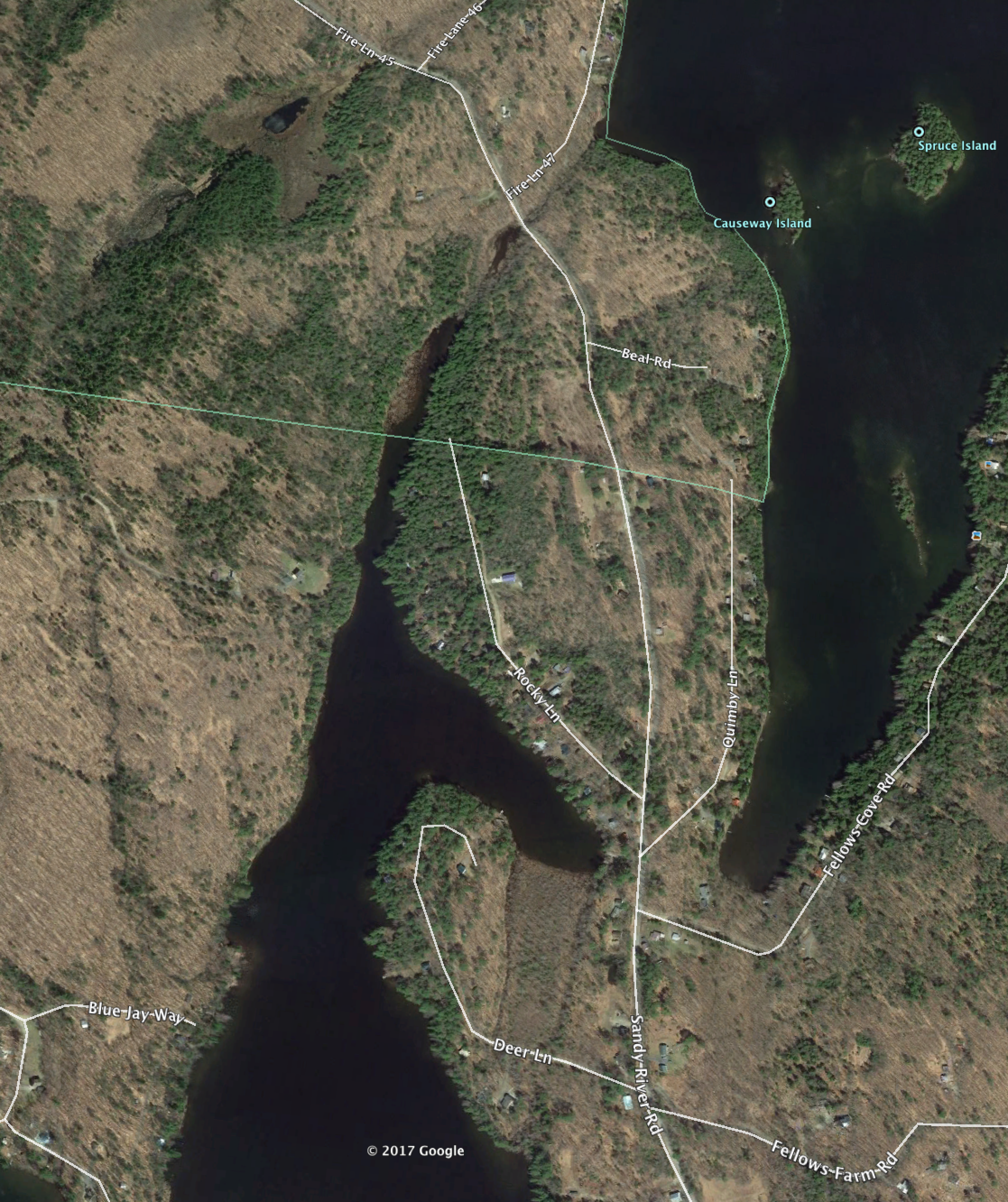
Photos of the Impoundment Area
TESTIMONY FROM RESIDENTS
Submissions from David Pond residents have been compiled here.
KENNEBEC JOURNAL ARTICLES
Posted online on 8/4/2017, and printed (front page above the fold) in Saturday 8/5/2017 edition.
Posted online on 12/25/2017.
GOVERNMENT DOCUMENTS
7/17/2017 FAYETTE BOARD OF SELECTMEN A recording of that meeting is no longer available.
LETTER FROM DUSTIN DORR (DEP) TO TOWN OF FAYETTE
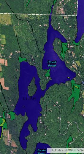
US FISH & WILDLIFE NATIONAL WETLANDS INVENTORY
STATE OF MAINE DEP REGULATION OF WATER LEVELS AND MINIMUM FLOWS
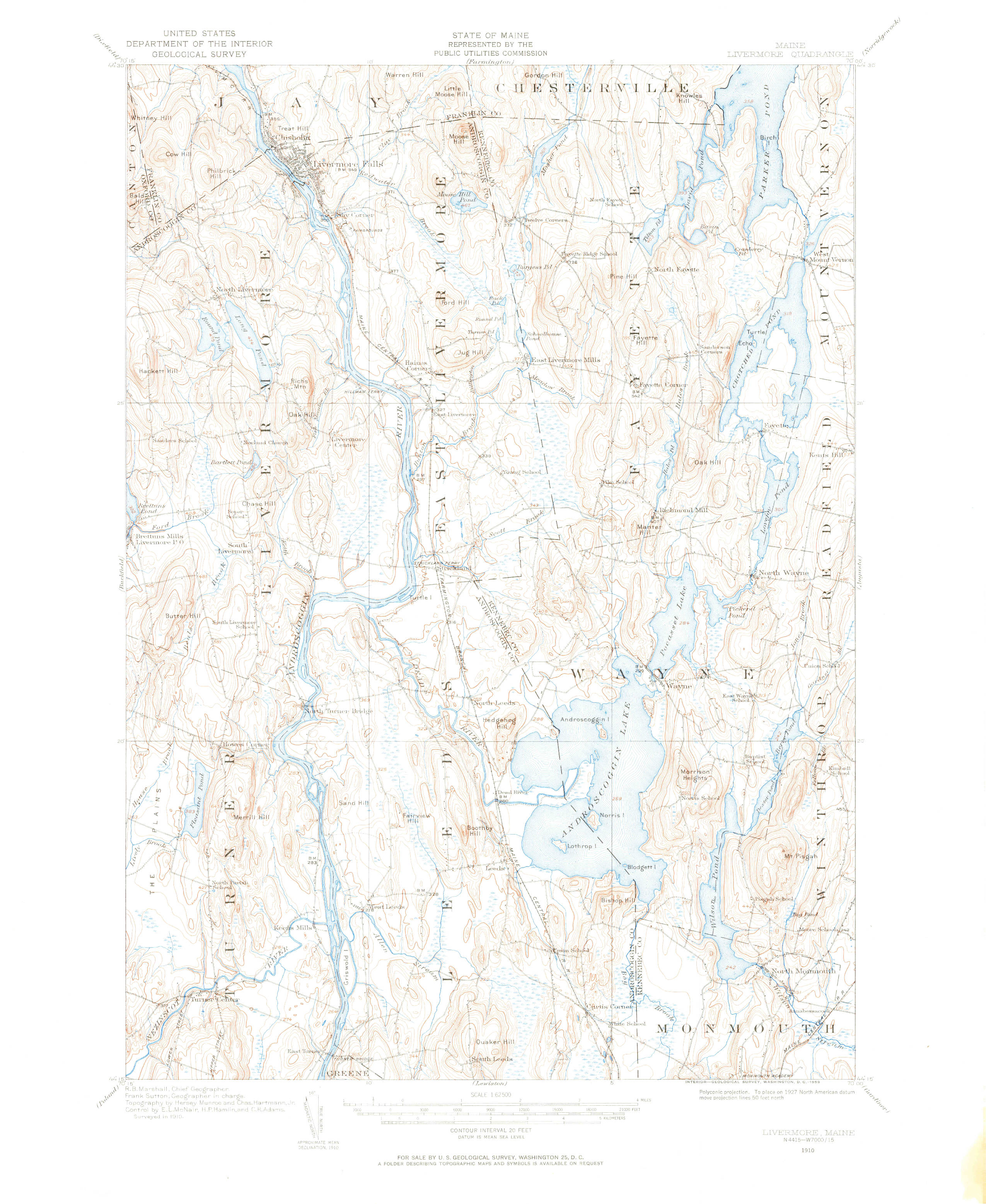
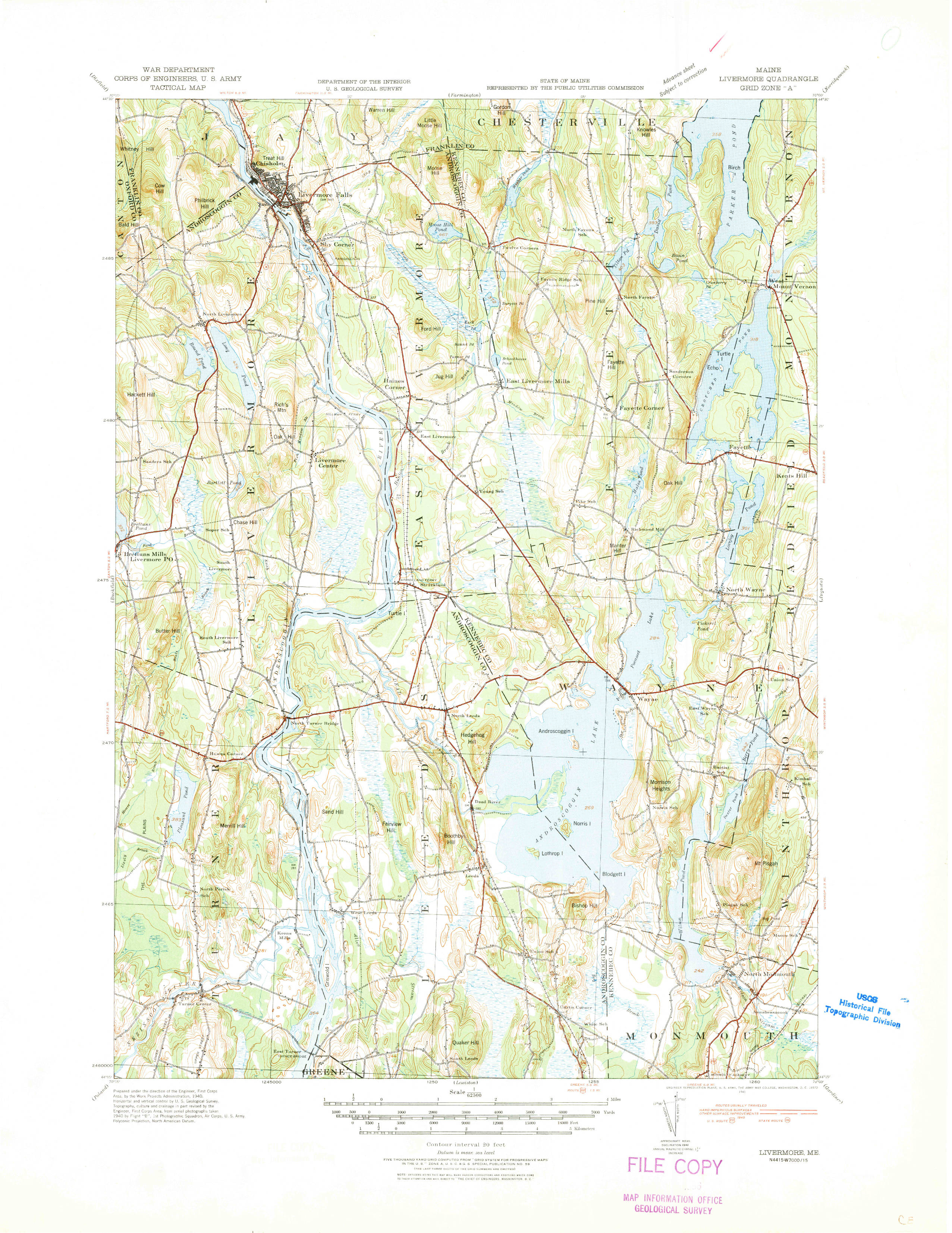
See below five USGS topographical maps dating back to 1910 that show a two foot water level decline from 1941 to 1986:
DAVID POND TOPOGRAPHICAL MAP 1910
DAVID POND TOPOGRAPHICAL MAP 1912
DAVID POND TOPOGRAPHICAL MAP 1941
DAVID POND TOPOGRAPHICAL MAP 1966
DAVID POND TOPOGRAPHICAL MAP 1986
More images and government data:
DAVID POND TAX SPREADSHEET (Fayette 2016)
LAND USE MAP This map shows protection areas, but also shows some property boundaries in detail
LANDOWNERS AT THE IMPOUNDMENT AREA
LETTER FROM LANDOWNERS 8-7-2017
ARCHIVE OF MESSAGES TO THE DAVID POND WATER LEVEL INTEREST GROUP DISTRIBUTION LIST
HISTORICAL EVIDENCE
HISTORY OF CHESTERVILLE, MAINE by Sewall, Oliver, 1788-1861
This history was based on the journal of Olivar Sewall, and was published fourteen years after his death in 1875. Note section 56 describes Wing’s Mills in the year 1805 at the location “ on a stream rising in Fayette and falling into Parker's Pond”. The current impoundment site is the only location that fits that description. Click the title for a link to the entire work.
HISTORY OF CHESTERVILLE, MAINE by Geo. J. Varney, Published by B. B. Russell, 57 Cornhill, Boston 1886
Relevant quote from this text (in second paragraph):
“At South Chesterville, situated on Parker’s Pond, there are a lumbermill and a grist-mill.”
This reference provides evidence that the mill was still functioning in 1886 when this book was published.
See BDTPA News Page for more recent updates.
This map was produced by Kennebec Journal staff.
